@WheresThatSat is a Twitter bot that knows where satellites are. Ask it about a satellite, and it will respond with the satellite's present coordinates and a link to more detailed information.
Acknowledgements
Many thanks to CelesTrak for providing current satellite data in the form of two-line element sets.
This website is hosted on Github Pages. The maps are produced with help from the following scripts and services:
- Google Maps API V3
- RichMarker from Google Maps Utility Library V3
- Query String Parser by Jon Wolter
The @WheresThatSat Twitter bot is written in Ruby and relies on the following libraries:
- The Twitter Ruby Gem
- Ruby Geocoder by Alex Reisner
Last but not least, @WheresThatSat uses Ground Track Generator to calculate satellite locations and attributes.
Feedback
Help make @WheresThatSat better. Bugs? Ideas? Let me know.
- Send questions and comments to @WheresThatSat on Twitter.
- Email longer inquiries or more detailed feedback to WheresThatSat@gmail.com.
- Report bugs or fork the code at Github.
Crew
Made by Jim DeVona. I'm presently stationed on Spaceship Earth, but I'm available to work on other spacecraft systems, too. Send me an email.
Other Sites
There are many other cool satellite tracking sites and services, some with Twitter integration. Here are a few:
Many more listed at HobbySpace.com.
Chatting with @WheresThatSat
Mention a satellite in a tweet to @WheresThatSat, and it will reply. Periodically it may report the location of other satellites as well.
Here's an example. I asked @WheresThatSat about the Hubble Space Telescope, and a few minutes later it replied:
@anoved When you mentioned Hubble Space Telescope, it was above 24.6206S 74.6625W. Here's more info: wheresthatsat.com/map.html?sn=Hu…
— Where's That Sat? (@WheresThatSat) April 25, 2012
Here is the list of satellites that @WheresThatSat knows about. If you mention multiple satellites, it will send multiple replies.
Maps and Details
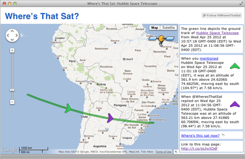
The link that @WheresThatSat includes in each reply leads to a page containing a map of the satellite's recent position. It looks like this:
The map shows the satellite's path from a few minutes before you mentioned it (pinpointed by the green arrow) to a few minutes after @WhereThatSat replied (pinpointed by the purple arrow).
The sidebar gives details on each key point, including latitude and longitude as well as altitude and velocity (speed and heading).
Observer Location
If your tweets are tagged with a location, @WheresThatSat will also report whether the satellite was potentially visible from your location, based on three factors: whether the satellite is illuminated, whether it is above the horizon, and whether the sun is below the horizon. Other factors which may influence visibility that are not taken into account include weather, topography, and satellite size.
#Places
If you prefer not to add a location to all your tweets, or if you just want to know if a satellite was visible from some other place, you can use the special #place hashtag to explicitly specify an observer location. Describe the location in quotes after the tag, like this:
@WheresThatSat GeoEye 1 #place "Herndon, Virginia"
— Jim (@anoved) April 25, 2012
Here's the response; GeoEye 1 was not visible from Herndon, VA.
@WheresThatSat understands many kinds of place descriptions, including street addresses, city names, and latitude/longitude coordinates. However, if the description is ambiguous, the intended location may be misinterpreted.
#Times
You can use the #time tag to find out where a satellite was or will be at a specified time. Currently only relative times such as #time "4 hours from now" or #time "15 minutes ago" are understood.
